All Newsletters
[Newsletter No.43] Korean Satellite to Monitor Forest Changes in National Parks
CBD-CHM Newsletter Vol. 43
Korean Satellite to Monitor Forest Changes in National Parks
The Korea National Park Service (KNPS), under the Ministry of Climate, Energy and Environment, announced that its recent analysis of forest changes in national parks using radar imagery from NEXTSat-2 found that radar signals vary depending on forest type.
The study demonstrates that domestically developed satellite data can be used to continuously monitor forested areas day and night, even under conditions such as cloud cover and fog that make observation difficult.
Using repeat observations collected from March 12 to September 20, 2025, the National Park Research Institute (NPRI) of KNPS produced time-series imagery and mapped the locations and patterns of changes in forest signals for each observation period.
NEXTSat-2 is a synthetic aperture radar satellite developed using domestic technology by the Korea Advanced Institute of Science and Technology (KAIST). Launched aboard the Nuri launch vehicle on May 25, 2023, it has continued to conduct observations using synthetic aperture radar (SAR)1).
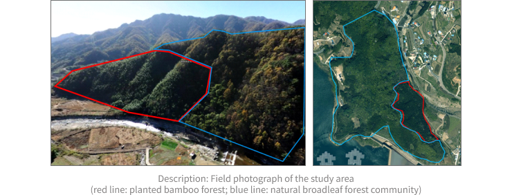
NPRI’s analysis of backscatter intensity2) in satellite SAR imagery revealed distinct backscattering characteristics in broadleaf forests and plantations in the study area, Jirisan National Park. For example, an analysis of backscatter intensity based on five observations of the Sancheong area of Jirisan between March and September 2025 showed distinct differences between broadleaf forests and plantations around a backscatter intensity value of 10,000. The findings indicate the potential to detect changes in forest structure by tracking variations in backscatter intensity in the two vegetation types over time.
Through the satellite imagery analysis, NPRI established a basic framework for analysis that can be further refined and applied to forest type classification, identification of areas suspected of degradation, and forest change detection.
In particular, repeated observations over time can be used to facilitate the early detection of forest decline, damage caused by pests and diseases, wildfire damage and subsequent recovery, areas at risk of landslides, and land-use changes.
Forests in national parks are ecosystems that are highly sensitive to climate change. Subalpine conifers such as the Korean fir (Abies koreana), in particular, are vulnerable to rising temperatures and extreme weather events such as droughts and heavy rainfall, underscoring the need for long-term monitoring that combines satellite data with field surveys.
“NEXTSat-2 data provide an important means of monitoring changes across the extensive forests of national parks at more frequent intervals,” said Dae-young Joo, Chairman of KNPS. “Going forward, we will integrate data from satellites, unmanned aerial vehicles (UAVs), and field surveys to detect changes in forest ecosystems vulnerable to climate change at an early stage and strengthen the scientific basis for responses to disasters such as landslides and wildfires, as well as for conservation and restoration policies.”
1)
SAR (Synthetic Aperture Radar) produces images by transmitting microwaves (radar signals) toward the Earth’s surface and analyzing the signals backscattered from the surface.
2)
Lower backscatter values generally indicate smooth surfaces or areas with high moisture content, such as lakes and flooded areas, while higher values indicate rough surfaces, such as dense forests.